Envisat, launched in 2002, was the largest Earth Observation (EO) satellite ever flown. Its multi-instrument capabilities and polar orbit allowed it to provide continuous observation and monitoring of the Earth’s land, atmosphere, oceans and ice caps. Unfortunately, Envisat’s mission ended in 2012 when communication with the satellite was abruptly lost, and efforts to re-establish contact were unsuccessful.
Some of Envisat's Mission Milestones
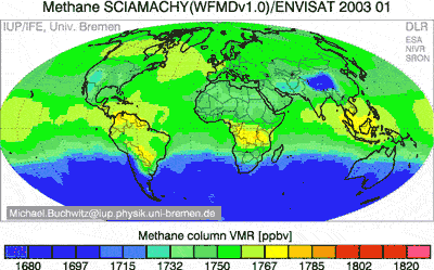
The first animation ever produced showing the global distribution of methane, the second most important greenhouse gas. Dr. Michael Buchwitz and Oliver Schneising from the Institute of Environmental Physics (IUP) at the University of Bremen in Germany produced the animation using Envisat SCIAMACHY observations from 2003 to 2005. Credit ESA
This image of the Larsen B ice shelf is one of the first photos taken by Envisat on 18 March 2002. Prior to Envisat’s launch, ERS-1 and -2 had been monitoring changes in the region. Together with ERS data, this image (orbit 250) documents the 100-km retreat of the Larsen B ice shelf. Today, Envisat's radar continues to make regular, all-weather observations to enable detailed studies of the extent, surface motion and surface melt of all the ice shelves around Antarctica. Credit ESAIn this image taken on 19 April 2010 by ESA’s Envisat satellite, a heavy plume of ash from the Eyjafjallajoekull Volcano in Iceland is seen travelling in a roughly southeasterly direction. The plume, visible in brownish-grey, is approximately 400 km long. The eruption led to the closure of airports throughout the UK and Scandinavia, with further disruption across northern Europe, as it poses a serious danger to aircraft engines.